

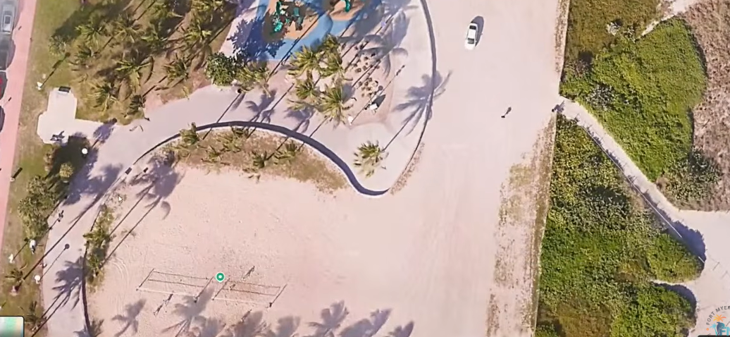
Fort Myers Beach gets first look at wave mitigation wall study
Fort Myers Beach Councilmembers, some of whom have been advocating for a wave mitigation wall in the town, had their first look into a study the town council authorized that could lead to wave mitigation walls as high as eight feet being placed on the island.
At a management and planning session this past week, the council heard from JR Evans Engineering, which contracted with the town for a $74,500 wave mitigation wall and shoreline protection due diligence study last year. Elizabeth Fountain, Senior Vice President, said the firm conducted a drone study analysis. “We did an island-wide special analysis to document surge information available through FEMA. Coastal construction line boundaries, jurisdictional boundaries and site specific wave propagation modeling analysis for the top elevation of the walls and structures to mitigate the wave action enough to lower the risk of damage to landward structures.”
The proposals include the placement of mitigation walls that could rise more than eight feet, though Fountain said that is the base elevation, and could be three or four feet or so above the height of the sand.
The concept of a wave mitigation wall has been controversial, as seawalls were historically opposed by many in the town during previous proposals as part of development projects, such as the former Grand Resorts project.
Opponents of the plans are concerned that the walls could lead to erosion of the beach around the wall. Seawalls in other parts of Fort Myers Beach have encountered erosion issues that necessitated town beach renourishment.
Austin Wise, who took part in the presentation, said there are critical high velocity zones with high wave action and medium wave action in the town that the wave mitigation walls could assist with. Wise said the town may need not only wave mitigation walls on the beach side, but the bay side as well near San Carlos Bay. “The northern end is very exposed,” he said.
Wise said the problem Fort Myers Beach has during storms is the water “doesn’t really have anywhere to go until it stacks up.”
Fountain said they modeled five locations for wave mitigation walls, with a required elevation of seven and a half feet to eight and a half feet high.
To determine the height of the wave mitigation walls that will be needed, the study focused on the areas of the shoreline where the “there was a more concentrations” of businesses, public spaces, single-family homes and condominium uses,” Fountain said.
The walls would be located on the beach in front of residential areas.
Fort Myers Beach Mayor Dan Allers, a proponent of the wave mitigation walls, cut into Fountain’s presentation to say “just for those paying attention out there, when you see eight feet, that is not eight feet on top of the sand.”
Fountain said that is beach level. The elevation of the beach could be considered four to five feet in some parts, she said. Fountain said Estero Boulevard is considered five feet above the beach elevation.
“People are going to take that and think it is a three feet wall all the way down,” Allers said. Allers asked how the walls would impact the sand berm project, which he said it is about six feet. “How close would that be in relation to the sand berm?”
Fountain said the walls would be landward of the berms. “A second line of defense,” she said. Fountain said the walls wouldn’t interfere with the beach dunes and sand berms. “You are not going to be able to rely on that sand indefinitely. It will be removed when storms come through.”
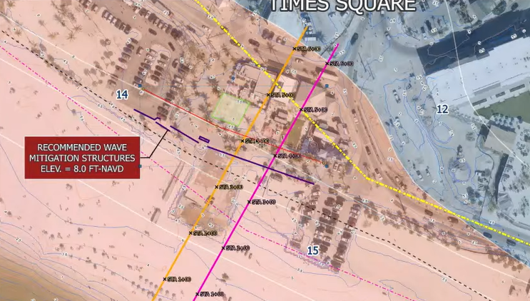
While Fountain said at that point in the presentation that the wave mitigation walls would be located landward of any existing sand berms or dunes, though during another part of the presentation a map rendering showed the wave mitigation wall going across the beach near Lynn Hall Memorial Park and Times Square.
Allers said “this will go right through the middle of a property owner’s property, which they are probably not going to be very happy with,” Allers said during a presentation of one of the illustrations. He pointed out the walls would be located well behind the coastal construction line.
“We are not saying the structure could not be out that far though it will be a pretty heavy lift with (state) permitting,” Fountain said. “It helps if there is an existing wall in the area we can reference. The wall need to be higher the further seaward you go, because the waves are higher.”
If the walls are moved further inland, the elevation of the height of the wall could be lower. The further out to the beach, the wave wall would need to be higher and strong to mitigate the waves.
Fountain said the walls are meant to withstand a 100-year flooding event.
Allers asked if the wall could disappear once the sand is pushed up against it. “That can happen,” Fountain said.
“The sand will help not only with the wave action but help limit sand transport” across Estero Boulevard, she said. Fountain said they are currently conducting analysis to prove that.
What the walls will not be doing is preventing a surge, Wise said. The walls allow the surge to go through, in fact. During a presentation of one of the model concepts, Wise said “what we are doing here is not stopping the surge. The really important thing folks is we are breaking the waves, we are not stopping the surge. The surge, it’s not something that is feasible to stop, it’s not reasonable but by breaking the wave action we can protect the property behind it very well.”
The surge is allowed to go through. The wall would look continuous, he said. The waves will be broken, he said.
Wise said JR Evans Engineering has a disagreement with FEMA currently over delineation in the island’s mapping of a primary frontal dune, which Wise said doesn’t exist on Fort Myers Beach. Wise said the firm would need to work around that.
On another presentation, Wise showed a wall with an elevation of 8.25 feet near residential structures at the 3562-3564 Estero Boulevard area. The wall would be located close to two homes on the beach side, along with potentially a series of walls.
Councilmember John McLean asked if there could be concrete stairs around the wall.
Fountain said there could be a boardwalk built. “There is an opportunity to do a walkover,” Fountain said. Fountain said the wall doesn’t need to be straight. “We can provide breaks,” Fountain said. The property owner would need to give approval for that.
At Newton Beach Family Park, the height of wall would 8.5 feet high and would also be close to homes nearby. “There would need to be some sand added here,” Wise said. Allers questioned if the data was accurate based on sand that was being placed there.
The third location studied was near 8300 Estero Boulevard, on the southern top of the island which is near Castle Beach Condominiums and Carlos Pointe Beach, also known as Mulholland Pointe.
Wise suggested placing dunes as an opportunity “not just for wave mitigation but for more comprehensive ecological restoration.” The area is also near where much of the island’s shorebird nesting takes place.
Fort Myers Beach Councilmember Rebecca Link asked about scour protections that Fountain mentioned near the walls. Fountain said there could be splash pads, a concrete pad or additional rock behind the wall.
Link said she is concerned with the sand eroding on the seaward side due to the wall.
Wise said he would prefer to see scour protection on front of all of the walls that are built. “Sometimes we face difficulty with that because of restrictions for sea turtle nesting,” Wise said. “Sometimes those rocks are considered obstructions to sea turtle nesting and they are not allowed. The alternative to that is to create a stronger wall with a deeper panel and then if you ever do have a storm where the beach is scoured out, just replacing that sand.”
Wise suggested the town create a series of dunes near the lagoon nearby.
Councilmember John King pointed out that is in the Little Estero Island Critical Wildlife Area and near the shorebird nesting areas.
Fountain said her firm has taken part in the planning of walls erected at Marco Island and Bonita Beach.
Fountain said they are working with property owners at Times Square and on a wave mitigation wall proposed by London Bay at the Outrigger Resort. Fountain said the London Bay mitigation wall for the Outrigger Resort property has preliminary approval from FEMA.
Fountain suggested the town survey the public on what they would like to see around the mitigation walls, such as shade structures, bike racks or seating areas.
Allers said shade structures “will be a popular one.”
Fountain suggested a “pilot project” at 1240 Estero Boulevard. Allers said the “property on the other side” may want to discuss a pilot program “if they are going to do it anyway.”
“I have talked to both of those property owners and they may want to be involved,” Allers said.
Allers did not respond to an email seeking more clarity about the location and property owners involved.
At a council meeting to approve a business project at Times Square several months ago where the property owner needed town council approval, councilmembers were asking if the property owner would be willing to pay into a fund to support a wave mitigation wall. Another Times Square property owner who recently submitted plans to the town, also detailed support for a wave mitigation wall in their plans.
The council is expected to be provided another update from JR Evans Engineering before deciding how to pursue a wave mitigation wall, or walls, and how it would be paid for.
Fort Myers Beach Observer Editor Nathan Mayberg can be reached at NMayberg@breezenewspapers.com